|
The
art of making scaled maps and plans seems to have vanished with the Babylonians
around the 8th century BCE, since no scale maps have been found dating
from the end of that Empire--until the Romans. From the Assyrian Empire,
which followed the Babylonian, we have only picture maps, not scaled maps,
appearing on the bas-reliefs found in Assyrian lands
between the 8th and 6th centuries BCE. We find in the Greeks a paucity
of any kind of topographical mapping at all; and while there is a tradition
of topographical mapping with the Egyptians, there is no discovered
instance of scaled mapping or plans.
However, in the Roman Empire we have clear evidence, as shall be shown,
of scale maps and plans. They had a tradition of picture maps which in
actuality were used to show the collected volumes of the surveying
treatises. After the first century CE a parallel system was apparently
developed related to the surveyed maps. It seems that in the Roman Empire
the surveyors themselves were responsible for drawing these maps/plans,
and drawing them to some kind of scale.
The treatises tell us that it was the surveyor who was responsible for
laying out lands for tillage while at the same time determining the ownership
of the units surveyed. They then prepared a plan forma) with copies to
both the local administration and the imperial archives. There are two
treatises which have been found, Frontinius and Hyginus, both of which
were written in the late first or early second century CE. These treatises
indicate that the plans should be engraved on bronze and should
act as a permanent record.
Only one group of plans of this sort is known to us at present. It was
a plan carved in stone and comes from the city of Orange (Arausio) in
modern-day Provence. A few carved fragments have long been known, but
between 1949 and 1955 many more carved stone pieces were found--so many
in
fact that it was possible to arrange the 443 pieces recovered into three
different such plans. Apparently each of these stone plans were affixed
to a wall and was of a significant size. Plan B, the one best represented
by the recovered pieces, is estimated to have been eighteen feet high
and twenty-three feet long, and made up of a minimum of four rows of stone
tablets.
 (1)
(1)
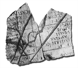
Figure
(1) is one of the fragments. It is carved in marble and reflects a plan
of fields near Orange. These plans were apparently laid out by the centurianation
method and completed in the late first century CE. There
are two vertical lines down the center of the fragment delineating a main
axis of the survey. Two roads cross it diagonally, following either bank
of a small stream with an island in it.
 (2)
(2)
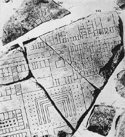
Figures
(2) and (3) show a much more ambitious plan, also carved on marble, also
probably erected on a wall. This was the plan of the city of Rome and
is known as the "Forma urbis Romae. It was of enormous size for a
scaled plan, some 42 feet high and 60 feet long, drawn to a scale of 1:240.
It was made up of a total of 151 tablets arranged in eleven rows.
|
 (3)
(3)
All that
remains of this map is 679 fragments and drawings of a further thirty-three
fragments from the sixteenth century, since lost. The above figures show
Rome as it was around 203 - 211 CE. The Forma, which was on display in
a public place, is extremely detailed and shows virtually all of the physical
features. The plan is remarkable for the period due to its general accuracy
and cartographic sophistication.
 (4)
(4)
 (5)
(5)
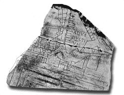
Figures (4)
and (5) are scaled plans which show that the Roman surveyors were capable
of constructing maps of great complexity to a consistent scale. The above
figures are the only surviving fragments of two carved scale-plans by
Roman surveyors. They clearly belong to the same tradition
as the third-century plan of Rome (figures (2) and (3), while differing
in just a few details. Figure (4), which was discovered in Rome, shows
private dwellings with the owners names inscribed on the fragment. Figure
(5), from Ostia, appears to be of a workshop area; the carved letters
appearing on the plan may be either a numbering system of the city blocks
or a measurement notation.
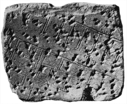
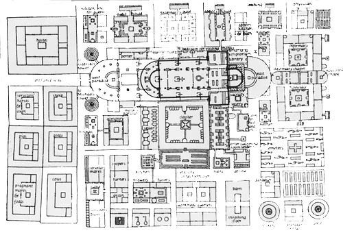
Figure
(6) is the last known map drawn in the tradition of the Roman surveyors.
It is a map which has been greatly simplified. It contains the Latin place
names translated into English. The plan appears to be of
a monastery complex drawn in the year 816-817 for Gozbert, the Abbot of
Gall in Switzerland. The author of the work is thought to have been Heito,
the Bishop of Basel and the Abbot of Reichenau. The purpose of the map
is obscure. The drawing seems to have been made at Reichenau, and it ended
as a scale-plan. The plan uses many of the Roman surveyors symbols, but
it also departs from the strict outline ground plans by picturing trees
rather than using dots as the Roman surveyors did. There are several other
commonalities, but many marks of difference as well. The design was drawn
to a scale of 1:192.
The union of surveyor and map-maker was restored during the Roman Imperial
period, as it had been previously achieved by Mesopotamia some two thousand
years before.
References:
- P.D.A.
Harvey, "The History Of Topographical Maps, Symbols, Pictures,
and Surveys," Thames and Hudson, London, 1980.
- John Noble
Wilford, "The Mapmakers," Alfred A. Knopf, New York, 1981.
|

 (6)
(6)